
I drive the two hours north to spend the night at my mother’s cute little apartment on a Tuesday, so that we can leave together early the next morning for our fall color tour. She has an itinerary in mind, and as we drive 4-plus hours north, she expresses her desire to fit in a trip to Lake of the Clouds somehow, though she has not been able to work it into our plans. We eat lunch at the park on the St. Ignace side of the Mackinaw Bridge, and after looking at the map, I think we could make it to Ontonagon by 6pm, allowing us to see Lake of the Clouds and then make our way up the Keweenaw Peninsula to our other planned destinations. At 78 years old, my mother has a remarkable store of energy and is driven by her desires. She’s always been this way. So we continue on, another 5 hours, finding sufficient lodging (which is the nicest way to put it) on very short notice in Ontonagon, after traveling a good 600 miles this first day, which lets us start at our farthest point and slowly make our way back over the next days. We walk out to Lake Superior just past sunset for a look, and then to the bustling local diner for a delicious meal.
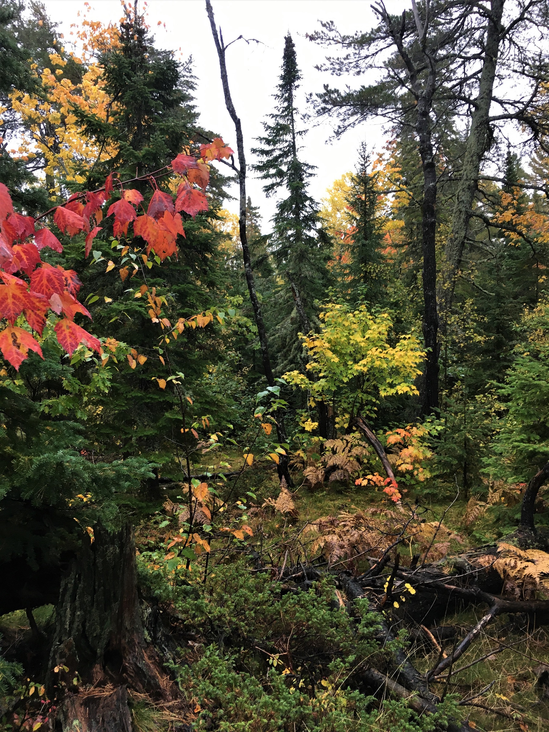
The next day as the sun rises over the sleepy little town, we head over to Lake of the Clouds. The 25-mile drive into the Porcupine Mountains along the Lake Superior shore crosses numerous rivers and creeks – Dreiss Creek, Weigel Creek, Potato River, Cranberry River, Little Cranberry, Townline – all spilling into the Great Lake to our right.
I’ve brought my film camera again and at the overlook to Lake of the Clouds, I haul myself onto the rock bluff while my mom walks along the boardwalk. After some time, I see my mom coming toward me, the rocky terrain not slowing her in the least, and we explore the views and some paths together.
Driving back toward the western edge of the Keweenaw Peninsula, she is not only patient with me as I stop to check out several of the creeks and rivers – Big Iron River, Mineral River, Patent Creek, Miles Creek, Pine Creek, Duck Creek – but understands that I must seize the moment and take the time to enjoy and explore while I can. At one such stop, she gets out with me, and as we are looking out over the bridge toward the rivermouth, a great Bald Eagle flies in and lands on the top of the tallest tree. The eagle periodically spreads her wings, to stretch perhaps or gain better balance, taking no notice of us as her gaze pierces the river and surrounding area.

We watch for a time, standing on the bridge on the quiet road, then continue on, eventually driving north through the teeming metropolis of Houghton, up the Keweenaw toward Eagle River. Along the route, she sees a sign for Cliff Cemetery and shouts “Stop!”, though there is no discernible path, parking lot, or roadway. We pull well off the side of the highway and head down the embankment into the woods until we find ourselves in a clearing of headstones and Celtic crosses overgrown with ivy. We quietly explore the old grave sites sinking into the soft earth in the hushed forest.
My mom has booked us a room at Fitzgerald’s in Eagle River, and after a delicious dinner with Lake Superior crashing just below the dining room windows, we walk in the moonlight around the town, and then sleep with the window cracked to the sound of the great waves breaking just feet away.

The next day takes us to Copper Harbor, across Brockway Mountain Drive, the highest paved roadway between the Rockies and the Allegheny mountains, and as the rain beats down, she tells me of the raptor migration that occurs each spring, with thousands of the birds alighting here before crossing Lake Superior. She is a wealth of information, again driven purely by her interests and desires to experience certain things (shouldn’t we all be?), and we talk of a tentative trip in the spring to witness their flight.

My daughter and son-in-law honeymooned in Copper Harbor just last June, and have recommended a hike they loved, but neither my mom nor I were listening very well and have just a loose idea at best of where the trail may be. The rain continues as we drive out past Lake Fanny Hooe, and make our way slowly along the dirt tracks filling with water. She is less concerned than I as we forge through huge puddles covering the road, my thoughts on the lack of cell service, the low frame, the unknown potholes or loosened earth invisible in the flooding.

We eventually find a trail and though she has informed me that she has to be careful to not fall on her brittle bones, I watch with envy as she scampers along more surefooted than I, reminding me of a chipmunk. We decide the trail, although beguiling, is not the one that the kids recommended, so we take our rain-soaked bodies back to a cozy hotel room looking out over the harbor, snuggled in for an afternoon of books and baths, our socks drying beneath the heater.

The snow begins on our last day in Copper Harbor, and though I’d been searching for a piece of copper jewelry to commemorate the trip and location, nothing has really spoken to me, until I see a pair of warm wool mittens, one hand decorated with a cloth the shape of the upper peninsula of Michigan, and the other with the lower peninsula. The mittens come with two little gems I can sew to indicate “where I live and where I love”. My mind has been on “where I live” the whole time in these places I love, and I find I’ve been silently hoping for a sign, something to tell me where My Next Move will take me. I’ll be selling my house in the spring, but that’s the extent of my plan at this stage. I talk for a long time with a young woman working at one of the many souvenir shops in Copper Harbor who has recently relocated to the tip of the peninsula from Metro Detroit. She says finding work is hard, and fitting in is hard, but then she goes into great and exuberant details about the rocks she is learning to hunt and recognize, and ultimately sell, and the group of people she is now connected with because of this new interest. She seems quite happy, as does Grandpa of Grandpa’s Barn, who greets us with “I am gainfully employed and get to live in this beautiful area” as his way of saying hello. (No need to ask him “How are you really?”!) The hostess at one of the restaurants also has an air of genuine joy, which she shares with us in many small ways as we chat after dinner, before heading back out into the sleet. It’s clear to me that I want to live in a place where people are happy. One step closer to figuring out a plan for myself.

I have a work conference on Mackinaw Island starting Sunday, so we make our way down the eastern edge through Bete Gris, Gay, following the shore of the majestic Lake Superior until we have to turn inland toward Lake Linden, to cross the only bridge over the waterway that splits the peninsula. Somewhere near L’Anse, we find another nice hike back into a river where I shoot the last of my 35mm film, and then drive the 300 miles to St. Ignace to catch the ferry to the island.